Saturday, October 1, 2016

Statewide Interactive Map of FDOT Speed Limits


Quite amazing how high speed limits are in the very hearts of cities, a danger to all, in particular vulnerable road users: people who bike, walk and roll.  Here's an interactive map of all state roads and some smaller roads.  Jump in a check out your city.   Useful to route planning.  In Daytona Beach note the speed limits on parallel routes ISB/US92 and Dr. Mary McLeod Bethune Blvd between White St and US 1.  Speeds on ISB/US 92 are 20 mph higher.   While US 92 has bike lanes, many people on bicycles are on the sidewalk, while on Bethune Blvd slower speeds prevail and people may
feel more comfortable, despite the lack of bike lanes.

Tuesday, September 13, 2016

Working on maps for the St. John's River to Sea Loop

The 260-mile St. John's River to Sea Loop is 30% complete and construction continues.  The Loop goes through Daytona Beach where it is also part of the East Coast Greenway.   The latest edition in Daytona Beach includes a wooden bridge under US92/ISB connecting the City Island Library and the News-Journal Center.   Here's a photo of Daytona's Sandy Cyclers on the new trail in early September.


Along the northern part of the Loop between St. Augustine and Palatka are smalls towns that invite agritourism.  A few sites are on this map (screen shot below). The GIS data were uploaded to Mapbox studio and legends and pop-up windows were coded in java script.


Sunday, June 12, 2016

A visit to Tucson: A Gold-level Bicycle Friendly Community

Get up early in Tucson in late May to enjoy the cool temperatures (70s) and Tucson's Rillito River Shared-Use Path!  Early rides provide great, long, morning shadows! About a 20 minute bike ride from the University of Arizona, this urban bikeway runs along both sides of the river on the north side of town. The trail goes under each major road crossing providing miles and miles a stress-free riding.


The ride between the Rillito path to the University is nice.  Mountain Ave has a buffered bike lane most of the way:

Mountain Ave also has signage to help prevent "right-hook" crashes in the bike lane at major intersections...


... and a button for cyclists to call for a green light:


As you approach the University, underpasses provide access to the main campus without crossing major street the borders campus and paths continue into campus to bike parking. 

Other bike routes are easily identified on Tucson's Bikeway map which conveniently folds to size of a business card: purple for off-road paths, green for on-road bikeways:


Apart from the wonderful shared-use paths and buffered bike lanes, Tucson offers bicycle boulevards along low-traffic streets.   Here sharrows, rather than bike lanes dominate, here's 3rd Street, a route I used to ride nearly everyday when I lived to Tucson 10 years ago.


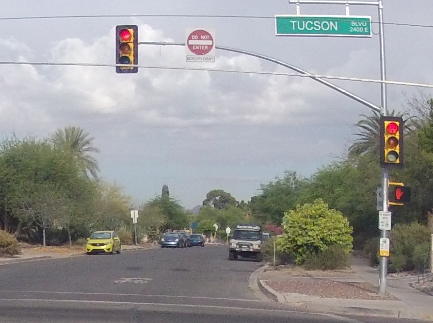
On the 3rd Street Bicycle Boulevard, cars may not turn on to 3rd Street from busy roads.  Note the DO NOT ENTER: BICYCLES EXEMPT sign and the sharrow leading the way:


Bike routes are also marked by signs where the bike routes intersect:  

One some routes, cyclists are channeled to use the cross walk to cross major roads:


At these here the ped and bike crossing run parallel and people on bikes get their own signal:


Note this crossing is a mid-block crossing for bike/ped, there is no crossing light for car traffic:


These routes provide regular sharrows with both a directions and a "share the road" message:


On major roads with regular bike lanes, wrong way signs on the road tell cyclists to bike in the direction of traffic:


So many great ideas here for other cities to steal.  Let's further prioritize bicycle travel!  We may not be Amsterdam, but can we at least be Tucson?

Local Connections:
Shared-use paths you can bike to:  The East Coast Greenway is coming along, just got a big boost as part of the St. John's River to Sea Loop will get $25 million in coming years.  The segment under the International Speedway Blvd/US 92 bridge opens July 14th at 5:30pm!


Protected/buffered bike lanes to the shared-use paths:  Beville Rd (SR 400) just got buffered lanes from Ridgewood Ave/US1 to west of Clyde Morris Blvd (SR 483).  


Other major arterial roads are behind: ISB, Nova, Clyde Morris, Williamson all have sections that are busy, very fast, and lack all infrastructure (except lanes for cars): no sidewalks, no shoulders, no bike lanes, etc. Safe travel on busy roads is important because few parallel routes provide connectivity due to closed-off neighborhoods and waterways.   We need to think about how to build
a low-stress highly connected network for bikeways.   I believe we first need a stress map, then we can start planning:


Friday, March 18, 2016

New National Report Ranks Florida on Biking and Walking

When it comes to biking and walking, how does
Florida stack up? A new report from theAlliance for Biking & Walking puts local and state efforts in perspective in Bicycling and Walking in the United States: 2016 Benchmarking Report.

The broad trend is clear: Walking and biking are on the rise across the United States. Active
transportation has broken through into the
mainstream conversation and been embraced by powerful stakeholders. But the real story is far more complex than a single trend line — or simple narrative.

Our transportation choices are significantly impacted by a wealth of different factors —
from gender to income to available infrastructure — and a new report from the Alliance for Biking & Walking illuminates these often overlooked indicators that shape American mobility.

Bicycling and Walking in the United States: 2016 Benchmarking Report collects and
analyzes data from all 50 states, the 50 most populous U.S. cities, and 18 additional cities
of various sizes. The report traces the rise of walking and biking and explores the intricate
intersections between transportation, health, economics, equity, government funding,
advocacy efforts — and so much more.

So where does Florida stand?

First the bad news:

Walking
● 39 pedestrian fatalities per 10,000 pedestrians in Florida (highest of all 50 states)
● 1.5% of commuters in Florida walk to work, behind the national average of 2.8%.  Jacksonville is last among the 50 most populous cities at 1.2%

Biking
● 4% of all traffic fatalities in Florida are bicyclists (highest of all 50 states)

(Mississippi is highest at 41 in the number of bicyclist fatalities per 10,000 bicyclists, 
Florida is at 23)

Better news:

● 0.7% of commuters bike to work, slightly higher than the national average of 0.6%
● $2.98 in per capita funding in Florida for biking and walking projects, higher than the national average of $2.47.  This is great for local jobs:

Also bicycling and bike share are good for businesses:


Read the full report here and follow @BikeWalk and #BikeWalk16 on Twitter for ongoing
conversation about the Benchmarking Report!

Sunday, March 13, 2016

Needed: a low-stress bicycle network for the Daytona Beach area

Imagine a city where traveling by bicycle is not only fun and healthy, but less stressful also.   San Jose, CA got low-stress bicycle network assessment, Daytona Beach should have one too!
Mapping streets by Level of Traffic Stress (LTS) should help prioritize what is needed to connect the lowest traffic stress neighborhoods of a city together into a large low-stress bicycle network!

A map like this has been made for San Jose, CA.


The study, Low Stress Bicycling and Network Connectivity,  found that most streets in the city had the lowest stress level, LTS =1, but they are isolated from each other.

The study suggested improvements, marked in orange:

These changes greatly increase the size of the network for bicycle travel less than or equal to LTS=2 (Most Adults).

Here's a comparison of the network before and after the improvements:


Saturday, March 5, 2016

Bike There Presentation at City Island Library on March 5th, 2016

It was great to meet members of the Sandy Cyclers at my library presentation today!


Here's a link to my presentation PDF file
Many website links within the PDF presentation.  Check it out.

Sunday, February 14, 2016

State Roads 2008 vs. 2015: Keep those bike lanes coming!


I recently realized that showing examples of road diets on state roads in the Daytona Beach area was much better using Google Maps street view than in Google Earth where the resolution of the older satellite imagery is poor.
This made me realize how much as changed since 2008, two years after I started traveling everywhere by bicycle in the area.  These roads are gradually getting friendlier, but mostly in patches, here and there, that lack interconnectivity.  These really aren't true road diets, the number of travel lanes for cars isn't changing, the lanes are just getting narrower in most cases.  Along with moving paint, curbs and sidewalks are often improved as well. (Screen shots from NYC DOT Street Design Manual).  
Animated GIFs from Google Street View


Above is Clyde Morris Blvd near the ERAU campus (2008 vs. 2015).  Back in 2008 this road had no sidewalk despite connecting a college campus to apartments and a major grocery store less than 1.5 miles away. In 2015 there's a shared use path on the west side between campus and the grocery store and short sections of marked bike lanes like this one.


I recall the first night I saw crews repainting US 92/ISB in front of Mainland high school.  How cool!  Improvements still needed: The shoulder isn't marked as a bike lane west of here and the bike lane vanishes at major intersections (ISB @ Clyde Morris and ISB @ US1).  Can't wait to see the paint moved again when the 7-foot buffered lanes eventually come in.   I see the majority of people on bikes on the sidewalk.  I reason that the car traffic is just too fast for comfort for most people even when they have your own lane.


Here's Nova Rd (SR 5A) just south of Beville Rd (SR 400).  This lane narrowing treatment a few years ago put bike lanes all the way south to Dunlawton Ave and parts south.  This road is very fast and the narrow bike lane doesn't provide much comfort, but very welcome.  Car speeds on ISB can be as high, but ISB is generally more congested so not as fast as Nova Rd.   North Rd north of Beville is awful all the way in Ormond Beach.  Seek alternative parallel routes for now!  N. Nova road needs a road diet!


State Route 40 (Granada) in Ormond Beach is so hit and miss.  Bike lanes come and go on this busy roads with "Share the Road signs" taking there place.  Not too comfortable.   Here's a good patch looking east at the Orchard St light.  FDOT and Ormond Beach need to prioritize vulnerable road user safety over parking and connect a continuous bike lane from west of I-95 to the beach.


Ridgewood Ave (US1/SR 5) just south of Beville got a makeover in 2011, with bike lanes and sidewalk improvements south of ISB through to Port Orange.  The speed limit on Ridgewood is slower than Nova or ISB, making this lane feel more comfortable.    The bike lane vanishes in a few spots, most critically when crossing ISB.  Bike lanes at major intersections is something FDOT and the City need to work on.